|
The role of geographic information systems in monitoring the marshes in southern Iraq The Iraqi marshes between loss and damage))
2024-03-16

Researcher Alaa Yassin Mohamed
Master of Remote Sensing and Remote Sensing
The marsh areas are the largest ecosystem of its kind in the Middle East and Western Asia, and the area of this vast water swamp is about 16 thousand square kilometres, which is larger than the area of the State of Lebanon, and the marshes extend between three southern governorates: Maysan, Dhi Qar, and Basra, and are an integral part of the transit routes for migratory birds between continents, support for endangered animal species, continuity of freshwater fishing areas, as well as the marine ecosystem in the Arabian Gulf, in addition to their environmental importance, The marshes are an unparalleled human heritage and have been home to indigenous people for thousands of years.
The drying of this area, which covers an area of 20.000 thousand kilometers, is one of the richest regions of the country in biodiversity and biodiversity and the largest ecosystem of water bodies in the Middle East represented the largest environmental disasters in the world, as the speed of changes that occurred in the marsh environment in less than one decade was drained the largest freshwater water complex in the world in addition to the significant damage to biodiversity and the extinction of a group of endemic animals in the marshes in addition to the changes The rain regime in the region has undergone significant changes, the proportion of dust storms has increased, and there has been a significant decrease in the preparation of cattle and buffaloes in the marshes.
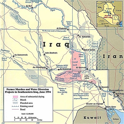
Map no. 1. Photo of the marshes of Iraq after drying in 1994
The health and immune status of the remaining numbers of animals has deteriorated due to the lack of green fodder. The lands covered with water constitute a vast area in the land of southern Iraq and this environment provides the right place for important gatherings of endemic and migratory wildlife and because this water environment is adjacent to the desert ocean, this has a significant impact on reducing desertification in the region and one of the important things that the marshes play is its entry as an essential link in the internal migration between continents for birds and fish, in addition to that this environment of water bodies that contain an exceptional natural heritage and an important and global genetic stock.
• The marshes occupied an area of 20,000 square kilometres before drying.
• More than 200,000 Marsh Arabs were forcibly displaced.
• The marshes turned into fronts.
• The United Nations has called the drain of the marshes a "tragic humanitarian and environmental disaster."
Climate system:
The drying of the marshes played an influential role in changing climatic conditions that have an impact on agricultural conditions and human life, as the tables that determine the climatic elements prove the clear impact of the ten years after the stage of drying the marshes, which concerns the monthly and annual rates of temperatures, maximum temperature rates and relative humidity, where you find large differences, the temperature rates for the ten years preceding drying were 23.9 m became in the nineties 25.17 m and the maximum temperature rates were 31.6 m became 33.2 The amount of humidity was 61%, it became 41%, and all this is due to the fact that the northwest winds prevailing in the region are now running on dry ground where there is no moisture in order to be the control in not rising temperatures.
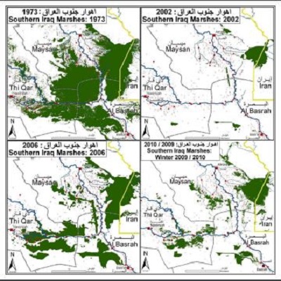
Map No. (2) Stages of draining the marshes Arabs are more vulnerable to climate change
• One quarter of the total area of the marshes compared to its previous area.
• Less than 1/2 of the indigenous population.
• Between 50-40% of them are completely dependent on water management services.
• Dry up large areas of marshes due to damage compatible between deliberate water scarcity and climate change.
• The majority of water purification plants located on the banks of the marshes are out of service and need rehabilitation.
• Increased salinity rates due to water scarcity and brine tongue approaching inland waters.
• Lack of awareness among communities about water management methods.
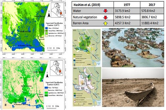
Figure (3) United Nations statistics for the stages of draining the marshes in southern Iraq
The drying up of this vast area of southern Iraq has led to:
1. High temperatures, low humidity and low quality of dates.
2. Increasing the water requirement of agricultural crops as a result of what the plant loses through evaporation.
3. Increasing the water requirement of agricultural crops as a result of what the plant loses through evaporation.
4. The departure of rare birds from the region.
5. The spread of salts in the soil and the ruin of their specifications.
6. The disintegration of soil particles, making it easier for the wind to lift atoms important for agricultural production.
7. The extinction of countless species of birds, plants and animals.
#university_of_anbar
#Upper_Euphrates_Basin_Developing_Center |